Projects and Initiatives
The themes central to our current projects are:
1) Character and timing of deformation and metamorphism on Sifnos, in the Cycladic Blueschist Belt, Aegean Sea , Greece
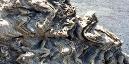
The island of Sifnos in the Aegean Sea , Cyclades ( Greece ) is well known for its spectacular and well preserved blueschists and eclogites. The best preserved assemblages occur in structurally high tectonic slices that outcrop in the north of the island. These slices occur in the upper-plate of a major detachment fault. The occurrence of eclogites and blueschist rocks overlying greenschists is a matter of debate, and contrasting interpretations have been proposed to explain the anomalous nappe stack.
A different interpretation implies that blueschists and greenschists derived from different structural levels, being juxtaposed during the exhumation history. Several exhumation mechanisms have been suggested, including extensional tectonics (Lister et al., 1984; Avigad, 1993), thrust tectonics (Lister & Raouzaios, 1996) and exhumation via an extrusion wedge (Ring & Layer, 2003). A detailed reconstruction of the decompressional P-T path may give information essential to discriminate among these different and contrasting models.
2) Character and timing of extension in the Cycladic Blueschist Belt in the Aegean Sea, Greece
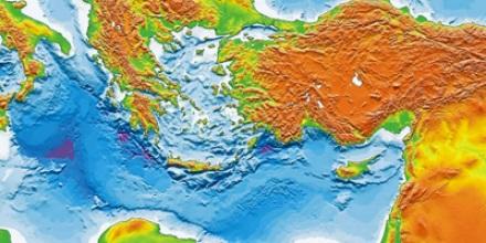
The Aegean Blueschist Belt is one of the most studied extensional zones on Earth. However still there is disagreement as to the complex tectonic history and exhumation of the HP/LT eclogite and blueschist rocks. New and extensive geochronology studies with meso-scale and micro-scale structural analysis of the complexly deformed central Aegean is being undertaken so as determine the different stages of evolution and to have a new look at the processes and models associated with the exhumation HP-LT rocks as well as a renewed look at the timing of extension in the Aegean micro-plate.
3) Character and timing of major movement zones beneath the Austro-Alpine 'cold' lid of the Western and Central Alps
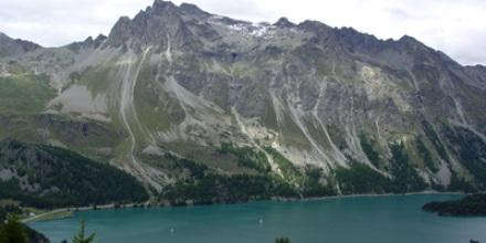
Complex arrays of laterally extensive movement zones occur beneath the Austro-Alpine 'cold lid' of the European Alps. These shear zones operated as extensional movement zones at various times during the tectonic evolution of the Alps, however meso-scale and micro-scale structural analysis show the tectonic history to be more complex with period of shortening and extension to have operated in a zone that we call 'Shuffle Zones'. Shuffle zones are characterized by slivers and/or lenses of exotic rock juxtaposed against rock metamorphosed and deformed at different pressure and temperatures during the tectonic history.
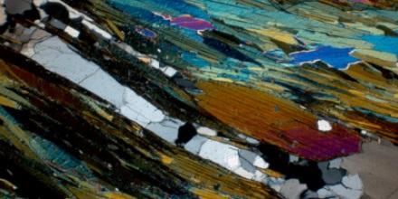
40Ar/ 39Ar geochronology is used to determine the timing of deformation across the crustal-scale shear zones and is used as a tool to define the deformation history of complexly deformed zones.
4) Oligocene extension on the south Cyclades shear zone, in the central Cyclades, Ios, Greece
Microstructural analysis with micro-scale based 40Ar/ 39Ar geochronology has been used to differentiate between different deformational events in the extensional zone of the central Agean Sea, Greece. North/south directed extension in the central Aegean has been largely accommodated by the South Cyclades Shear Zone. An 40Ar/ 39Ar geochronology study shows that extension in the Aegean started much earlier than previously thought, with the pervasive top-to-the-south shear zone operating during the Oligocene, predating the Oligo-Miocene extensional epoch.
Furthermore previous work suggests the pervasive top-to-the-south shear zone and the overprinting narrow top-to-the-north shear zone South Cyclades Shear Zone represent conjugate shear zones that operated during Miocene. Results from 40Ar/ 39Ar geochronology show that these two shear zones are not conjugate but operated at distinctly different times and that only the narrow top-to-the-north shear zones operated during the Oligo-Miocene epoch.
5) The virtual Earth
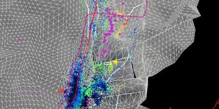
The Virtual Earth describes the real or material Earth - it is an electronic rendition of our planet as it is today. The aspect upon which we have specifically focussed is the geometric description of the planetary lithosphere, in particular the 3D geometry of the major subducting slabs. These geometries have been derived by examination of hypocentric datasets in combinaiton with images derived from seismic tomography (e.g. Richards et al. 2005).
The tomographic data has been analyzed in a way that emphasizes the median of any particular lithospheric slab. Errors of interpretation will abound, for seismic tomography is a science that is still in its infancy and ray-path density in many areas is too low to allow anything but subjective interpretation. Nevertheless, there are advantages to an overall assessment of possible geometry and the plethora of results that continue to emerge as the result of this analysis.
To contribute to its construction please contact one of us. Industry support is needed to allow The Virtual Earth to continue to the next stage of its development (universal grid-enabled access to the data as part of the AuScope NCRIS initiative).
Updated: 7 July 2020/ Responsible Officer: Structure Tectonics Team Leader/ Page Contact: WebAdmin


